Blosm for Blender (premium)

One click import of OpenStreetMap with textured buildings, forests, satellite imagery, terrain for Blender
In addition to the features of the base version, the premium one provides:
- Import of buildings from OpenStreetMap with default materials, tileable building textures and UV-mapping applied
- Default materials and textures to mimic lit windows for a late evening setting
- Import of forests and single trees as 3D objects
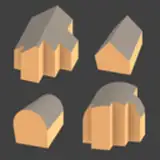
- An option to apply geometry nodes to OSM footprints to get realistic 3D buildings (more information)
- Options to use custom tileable building textures, for example from textures.com (a tutorial)
- Satellite imagery and web maps projected on a terrain
Subsequent releases will include more details and variability for imported buildings and other features depending on user feedback.
Important notice: the addon does not provide real textures for each imported building!
Important notice: export of textures is available as an experimental feature.
At the moment only one low-polygon model of a tree is provided with the addon. It's possible to use custom tree models for imported forests and single trees.
- Documentation
- e-mail: prokitektura+support@gmail.com
- twitter: @prochitecture
- facebook: @prochitecture
